Event Info » Course map and description
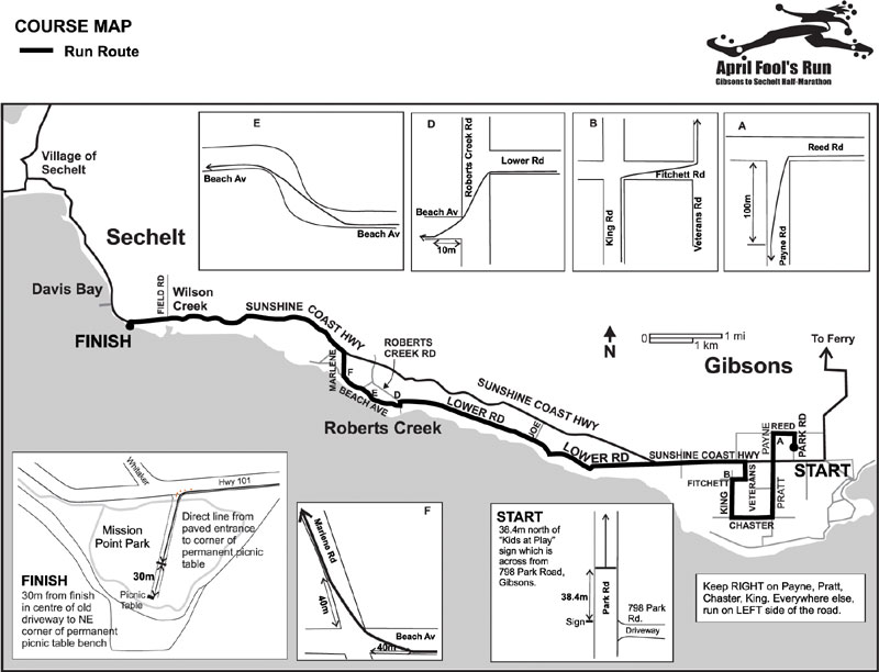
Course Map & Description
Finish line in beautiful Mission Point Park!
- Course Certification #: BC-2012-009-BDC
- Every km marked, as well as 1 mile, half-way and 400m to go
Interactive course map and elevation profile from RunningAhead.com. You can view in miles or km, see map or satellite view, zoom in or out.
NEW! Turn by turn directions sheet for Time Trial — print and carry with you
Printer-friendly course map (for Sunshine Coast area map see the Visitor Info page)
Elevation Profile
Net drop is 142m, but there is enough uphill to keep you honest! Come prepared for hills… don't say we didn't warn you! If you're looking for a flat course, this ain't it.
Course Description
Also see:
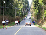
- Course Photo Tour
- Course Fly-Over Video by Keith Dunn
- History of the communities along the race route
The start is on Park Road about 300m north of the Community Centre. Proceed north on Park Road, up a short hill to Reed Road. Turn left onto Reed Road and go for one flat block then turn left down Payne Road. Straight down Payne (stay on the RIGHT side here) and across the highway continuing down Pratt Road. Stay on the right side when going down Pratt (there's a wide shoulder).
Turn right on Chaster Road, still staying on the right side, then right again at King Road. Straight up the right side of King Road (flat to slight incline) to Fitchett. Right on Fitchett (starting to climb), then left onto Veterans (climbing more here and using left side). From this point on you will be on the left side facing traffic. Crest the hill on Veterans and continue downhill to the highway, where you will turn left (ignore the frontage road) and head towards Roberts Creek. The first Relay exchange is at the end of Veterans.
Stay on the highway for less than a mile before turning left onto the very scenic and rural Lower Road (curves sharply to the right as soon as you leave the highway).
Lower Road drops down a major 3-part hill (known to locals as Cemetery Hill) then runs approximately parallel to the Highway right into Roberts Creek. While cruising along the forested road, you may catch a glimpse of the unique metal sculptures of Axel Stenzel at his home studio, and a beautiful ravine garden, both on your right. Much of this stretch is flat or slightly downhill. The second relay exchange is at Joe Road, about the midpoint of Lower Road.
Upon reaching the heart of Roberts Creek make a left turn onto Roberts Creek Road followed by a quick right onto Beach Avenue. Wind gradually uphill past beautiful beachfront properties, reaching the steepest portion at the S-curve. Soon afterwards there's a slight downhill to Marlene Road. Turn right and head uphill to the highway. This is the most challenging part of the course and you'll have to dig deep. The bottom of Marlene is fairly steep, then it climbs more gently up to meet the highway. The third relay exchange is near the bottom of Marlene.
Turn left on the highway and continue towards Sechelt, flat at first then uphill past the provincial campsite entrance. Then you can fly DOWN the nice big long hill. This hill is known to locals as 'Rat Portage Hill' for reasons unsure to us. Time to start your final push to the finish line.
There's one last gentle incline before the final descent to the flats of Wilson Creek. Start to pick up the pace here as you're nearing the finish line — it's pancake flat to the end! Immediately after crossing the bridge over Chapman Creek, take a sharp left into Mission Point Park. Watch for the bollard in the middle of the entrance. The last 50m or so is on short firm flat grass (used to be a driveway). Sprint!
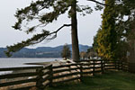
Mission Point Park is connected by short walking paths to Davis Bay Beach, with picturesque views across Georgia Straight to Vancouver Island. The pier, hotels and cafes are about 800m beyond the finish line, along the seaside promenade beside the highway.
“My GPS says the course was too long!”
Please be aware that GPS nearly always measures too long for a number of reasons, the main one being imprecise locating of each point, as well as you not running the shortest possible distance (tangents on each turn). Our course has been officially certified to be a correct half marathon distance, measured several times with a calibrated Jones Counter according to Athletics Canada standards.